Kelseyville, California
Appearance
Kelseyville, California | |
|---|---|
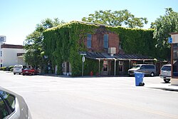
 Downtown Kelseyville | |
 | |
| Coordinates: 38°58′41″N 122°50′22″W / 38.97806°N 122.83944°W | |
| Country | United States |
| State | California |
| County | Lake |
| Area | |
| • Total | 2.891 sq mi (7.487 km2) |
| • Land | 2.885 sq mi (7.472 km2) |
| • Water | 0.006 sq mi (0.015 km2) 0.20% |
| Elevation | 1,384 ft (422 m) |
| Population (2020)[3] | |
| • Total | 3,382 |
| • Density | 1,200/sq mi (450/km2) |
| Time zone | UTC-8 (Pacific (PST)) |
| • Summer (DST) | UTC-7 (PDT) |
| ZIP code | 95451 |
| Area code | 707 |
| FIPS code | 06-38044 |
| GNIS feature ID | 0277532 |
Kelseyville is a census-designated place (CDP) in Lake County, California, United States. Kelseyville is located six miles (9.7 kilometers) southeast of Lakeport.[4] The population was 3,382 at the 2020 census.[3]
References
[change | change source]- ↑ U.S. Census Archived 2 July 2012 at the Wayback Machine
- ↑ U.S. Geological Survey Geographic Names Information System: Kelseyville, California
- ↑ 3.0 3.1 "Kelseyville CDP, California". United States Census Bureau. Retrieved August 29, 2023.
- ↑ Durham, David L. (1998). California's Geographic Names: A Gazetteer of Historic and Modern Names of the State. Clovis, Calif.: Word Dancer Press. p. 87. ISBN 1-884995-14-4.

